![](/images/other/stat-length.png)
![Tocht Stappen San Sebastián de la Gomera - La Gomera - La Zarcita la Laja el Bailadero 7/5/2019 - Photo](https://media.geolcdn.com/t/1900/400/f8d4614d-4c66-4ecc-89c4-7f24d5cd179e.jpg&format=pjpeg&maxdim=2)
La Gomera - La Zarcita la Laja el Bailadero 7/5/2019
fredetpascale
Gebruiker GUIDE
![Lengte](/images/other/stat-length.png)
Lengte
8,7 km
![Max. hoogte](https://static1.geolcdn.com/siteimages/upload/files/1508320355ic_sort_altitude_max_24dp.png)
Max. hoogte
1183 m
![Positief hoogteverschil](https://static1.geolcdn.com/siteimages/upload/files/1508320355ic_sort_den_pos_24dp.png)
Positief hoogteverschil
678 m
![Km-Effort](/images/other/stat-length.png)
Km-Effort
17,8 km
![Min. hoogte](https://static1.geolcdn.com/siteimages/upload/files/1508320355ic_sort_altitude_min_24dp.png)
Min. hoogte
511 m
![Negatief hoogteverschil](https://static1.geolcdn.com/siteimages/upload/files/1508320355ic_sort_den_neg_24dp.png)
Negatief hoogteverschil
689 m
![Boucle](https://static1.geolcdn.com/siteimages/upload/files/16400158638029165_repeat_loop_refresh_sync_direction_icon.png)
Boucle
Ja
Datum van aanmaak :
2019-05-07 10:12:40.409
Laatste wijziging :
2019-05-07 18:17:29.813
![Stappen](https://static1.geolcdn.com/sitytour/trail-icons/101.png)
3h39
Moeilijkheid : Medium
![Scan deze QR-code om de tocht te openen in de SityTrail-applicatie](https://capi.geolives.com/qq0zvz2zws4bq2lad0pu/sitytour/trails/2074863/qr.png?size=200)
Gratisgps-wandelapplicatie
Over ons
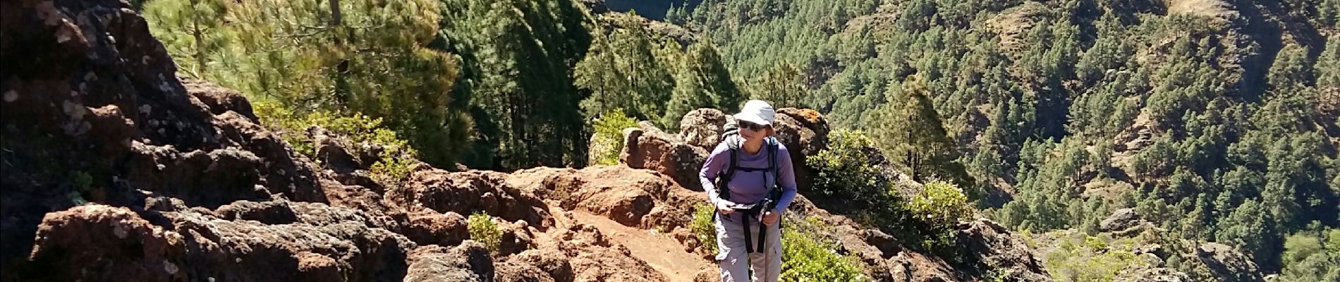
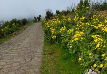
Tocht Stappen van 8,7 km beschikbaar op Canarische Eilanden, Santa Cruz de Tenerife, San Sebastián de la Gomera. Deze tocht wordt voorgesteld door fredetpascale.
Beschrijving
Rother 65 - Joli sentier en dehors de la route et chemin de descente panoramique.
Plaatsbepaling
Land:
Spain
Regio :
Canarische Eilanden
Departement/Provincie :
Santa Cruz de Tenerife
Gemeente :
San Sebastián de la Gomera
Locatie:
Unknown
Vertrek:(Dec)
Vertrek:(UTM)
282560 ; 3111077 (28R) N.
Opmerkingen
Wandeltochten in de omgeving
![Tocht Te voet Agulo - PR LG 3 - Photo](https://media.geolcdn.com/t/375/260/afef9a1d-8886-4d58-be0c-78363cbd237a.jpeg&format=jpg&maxdim=2)
![Te voet Te voet](https://static1.geolcdn.com/sitytour/trail-icons/100.png)
PR LG 3
Te voet
Gemakkelijk
Agulo,
Canarische Eilanden,
Santa Cruz de Tenerife,
Spain
![](/images/other/stat-length.png)
5,2 km | 7 km-effort
1h 35min
![](https://static1.geolcdn.com/siteimages/upload/files/16400158638029165_repeat_loop_refresh_sync_direction_icon.png)
Neen
![Tocht Te voet Vallehermoso - Laguna Grande II - Photo](https://media.geolcdn.com/t/375/260/fea34cc3-5ea7-416d-8acd-34e974e31bb6.jpeg&format=jpg&maxdim=2)
![Te voet Te voet](https://static1.geolcdn.com/sitytour/trail-icons/100.png)
Laguna Grande II
Te voet
Gemakkelijk
Vallehermoso,
Canarische Eilanden,
Santa Cruz de Tenerife,
Spain
![](/images/other/stat-length.png)
3,9 km | 5,5 km-effort
1h 14min
![](https://static1.geolcdn.com/siteimages/upload/files/16400158638029165_repeat_loop_refresh_sync_direction_icon.png)
Ja
![Tocht Te voet Hermigua - Reventón Oscuro - El Cedro - Photo](https://media.geolcdn.com/t/375/260/894e2729-5fef-471c-801f-1eaa4ed76d4c.jpeg&format=jpg&maxdim=2)
![Te voet Te voet](https://static1.geolcdn.com/sitytour/trail-icons/100.png)
Reventón Oscuro - El Cedro
Te voet
Gemakkelijk
Hermigua,
Canarische Eilanden,
Santa Cruz de Tenerife,
Spain
![](/images/other/stat-length.png)
3,2 km | 6,3 km-effort
1h 25min
![](https://static1.geolcdn.com/siteimages/upload/files/16400158638029165_repeat_loop_refresh_sync_direction_icon.png)
Neen
![Tocht Te voet Hermigua - Ruta 9: El Contadero - Chorro del Cedro - Photo](https://media.geolcdn.com/t/375/260/170a792b-f466-4df4-95eb-754e8c2f554c.jpeg&format=jpg&maxdim=2)
![Te voet Te voet](https://static1.geolcdn.com/sitytour/trail-icons/100.png)
Ruta 9: El Contadero - Chorro del Cedro
Te voet
Gemakkelijk
Hermigua,
Canarische Eilanden,
Santa Cruz de Tenerife,
Spain
![](/images/other/stat-length.png)
5,8 km | 11,4 km-effort
2h 35min
![](https://static1.geolcdn.com/siteimages/upload/files/16400158638029165_repeat_loop_refresh_sync_direction_icon.png)
Neen
![Tocht Te voet Hermigua - Ruta 11: La Meseta de Hermigua - Chorro del Cedro - Photo](https://media.geolcdn.com/t/375/260/9ee5583b-8203-4e03-a5fc-f7ea80c15335.jpeg&format=jpg&maxdim=2)
![Te voet Te voet](https://static1.geolcdn.com/sitytour/trail-icons/100.png)
Ruta 11: La Meseta de Hermigua - Chorro del Cedro
Te voet
Gemakkelijk
Hermigua,
Canarische Eilanden,
Santa Cruz de Tenerife,
Spain
![](/images/other/stat-length.png)
5,4 km | 9,2 km-effort
2h 5min
![](https://static1.geolcdn.com/siteimages/upload/files/16400158638029165_repeat_loop_refresh_sync_direction_icon.png)
Neen
![Tocht Te voet Vallehermoso - Ruta 14: Laguna Grande - Alto de Garajonay - Photo](https://media.geolcdn.com/t/375/260/fea34cc3-5ea7-416d-8acd-34e974e31bb6.jpeg&format=jpg&maxdim=2)
![Te voet Te voet](https://static1.geolcdn.com/sitytour/trail-icons/100.png)
Ruta 14: Laguna Grande - Alto de Garajonay
Te voet
Gemakkelijk
Vallehermoso,
Canarische Eilanden,
Santa Cruz de Tenerife,
Spain
![](/images/other/stat-length.png)
9,9 km | 14,8 km-effort
3h 22min
![](https://static1.geolcdn.com/siteimages/upload/files/16400158638029165_repeat_loop_refresh_sync_direction_icon.png)
Ja
![Tocht Te voet Alajeró - Ruta 16: Pajarito - Ajugal - Photo](https://media.geolcdn.com/t/375/260/de173e01-927b-4cca-bc9d-79cda4d5f77d.jpeg&format=jpg&maxdim=2)
![Te voet Te voet](https://static1.geolcdn.com/sitytour/trail-icons/100.png)
Ruta 16: Pajarito - Ajugal
Te voet
Gemakkelijk
Alajeró,
Canarische Eilanden,
Santa Cruz de Tenerife,
Spain
![](/images/other/stat-length.png)
6 km | 8,2 km-effort
1h 51min
![](https://static1.geolcdn.com/siteimages/upload/files/16400158638029165_repeat_loop_refresh_sync_direction_icon.png)
Neen
![Tocht Te voet Hermigua - Ruta 17: Pajarito - Alto de Garajonay - Pajarito - Photo](https://media.geolcdn.com/t/375/260/72d2f045-c0bf-444b-8c36-7a4692fcc430.jpeg&format=jpg&maxdim=2)
![Te voet Te voet](https://static1.geolcdn.com/sitytour/trail-icons/100.png)
Ruta 17: Pajarito - Alto de Garajonay - Pajarito
Te voet
Gemakkelijk
Hermigua,
Canarische Eilanden,
Santa Cruz de Tenerife,
Spain
![](/images/other/stat-length.png)
4,5 km | 6,3 km-effort
1h 26min
![](https://static1.geolcdn.com/siteimages/upload/files/16400158638029165_repeat_loop_refresh_sync_direction_icon.png)
Ja
![Tocht Te voet Hermigua - Gran Ruta 18: Circular Garajonay - Photo](https://media.geolcdn.com/t/375/260/57800df3-3f93-4db0-bd7e-1699504de0eb.jpeg&format=jpg&maxdim=2)
![Te voet Te voet](https://static1.geolcdn.com/sitytour/trail-icons/100.png)
Gran Ruta 18: Circular Garajonay
Te voet
Gemakkelijk
Hermigua,
Canarische Eilanden,
Santa Cruz de Tenerife,
Spain
![](/images/other/stat-length.png)
3,6 km | 4,5 km-effort
1h 1min
![](https://static1.geolcdn.com/siteimages/upload/files/16400158638029165_repeat_loop_refresh_sync_direction_icon.png)
Neen